
-
Original Article
-
Physico-Chemical Characterization of Substrate Materials for Green Roof Greening
인공지반 녹화를 위한 토양개량제의 이화학적 특성 분석
-
Junyoung Cho, Hyomin Kim, Minseo Kim
조준영, 김효민, 김민서
- As urban densification intensifies and climate change continues to erode city sustainability, green roofs have emerged as a promising form of green …
도시 고밀화가 심화되고 기후변화에 따른 지속가능성이 약화되고 있다, 옥상녹화는 토지 이용이 제한된 도시공간에서 적용 가능성이 높은 도시 생태 기능을 높이는 그린 인프라로서 …
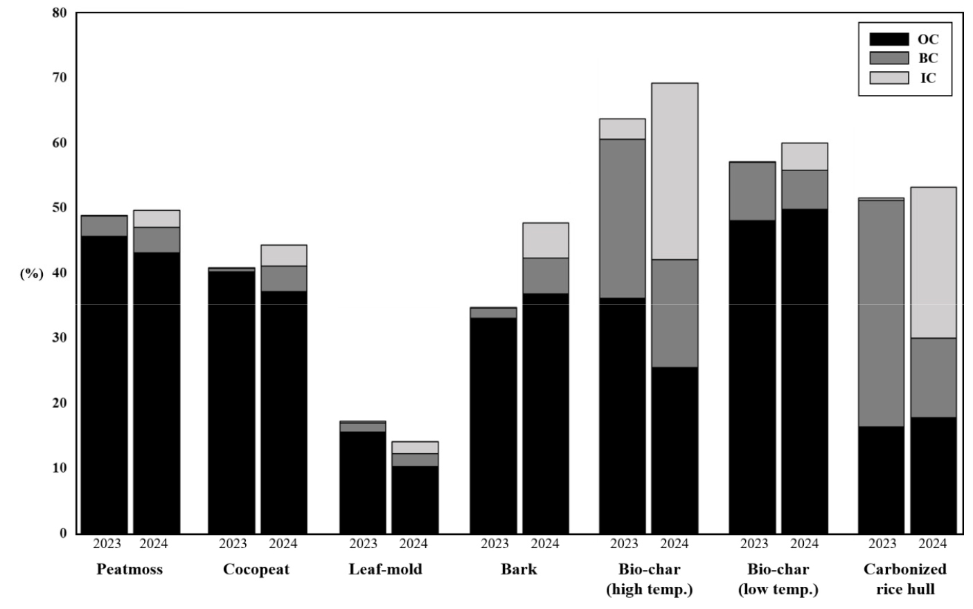
- As urban densification intensifies and climate change continues to erode city sustainability, green roofs have emerged as a promising form of green infrastructure capable of enhancing urban ecological functions in land-constrained environments. This study analyzed the physicochemical and carbon-related properties of engineered soils and substrate component materials used in green roof systems, with the aim of establishing baseline data for substrate material selection to support material sustainability and stable plant growth. Eleven materials classified into organic, carbon-based, and inorganic categories were examined: peat moss, cocopeat, leaf mold, bark, high- and low-temperature biochar, carbonized rice hull, bottom ash, vermiculite, zeolite, and perlite. Carbon fractions derived from thermogravimetric analysis (TGA)—total carbon (TC), organic carbon (OC), black carbon (BC), and inorganic carbon (IC)—were assessed alongside elemental composition and standard physicochemical parameters, including pH, electrical conductivity (EC), cation exchange capacity (CEC), and available phosphate (P2O5). Baseline measurements collected in 2023 were compared with follow-up measurements obtained in 2024 to evaluate temporal changes over a one-year period. The results revealed measurable shifts in physicochemical properties across multiple materials over time. Organic and carbon-based materials generally demonstrated higher total carbon contents and greater nutrient retention capacity, whereas inorganic materials were characterized by lower total carbon and CEC values but higher porosity, rendering them suitable as drainage-promoting amendments within substrate mixtures. These results quantitatively characterize the distinct physicochemical and carbon-related profiles of organic, carbon-based, and inorganic substrate materials, providing baseline data that may serve as a reference for future green roof growing media research.
- COLLAPSE
도시 고밀화가 심화되고 기후변화에 따른 지속가능성이 약화되고 있다, 옥상녹화는 토지 이용이 제한된 도시공간에서 적용 가능성이 높은 도시 생태 기능을 높이는 그린 인프라로서 주목받고 있다. 본 연구는 옥상녹화 시스템 자재의 지속가능성을 향상시키고 안정적인 식물 생육을 위한 재료 선정에 필요한 기초자료를 확보하고자, 옥상녹화 시스템에 활용되는 인공토양 및 토양개량제 구성 재료의 이화학적 특성과 탄소 관련 특성을 분석하였다. 분석 대상은 유기계, 탄소계, 무기계로 구분되는 총 11종의 재료로, 피트모스, 코코피트, 부엽토, 바크, 고온 및 저온 바이오차, 훈탄, 바텀애시, 버미큘라이트, 제올라이트, 펄라이트를 포함한다. 열중량분석으로 산정한 탄소 분획(TC, OC, BC, IC)과 원소 및 이화학 분석(pH, EC, CEC, P2O5)을 통해 초기 특성(2023)과 1년 후(2024)의 변화를 비교하였다. 분석 결과, 다수 재료에서 시간 경과에 따른 이화학 특성 변화가 확인되었다. 유기계 및 탄소계 재료는 전반적으로 총탄소와 양분 보유 능력이 높게 나타났다. 반면, 무기계 재료는 총탄소와 양이온교환용량이 낮고 공극이 많아 배수성이 큰 토양개량제로서 이용될 수 있다. 연구의 결과는 유기계, 탄소계, 무기계 재료군별로 pH, EC, CEC, 탄소저장량 등 이화학적 특성이 다르며, 1년간 옥상 노출 후에도 재료별로 상이한 변화 양상을 보임을 정량적으로 제시하였다.
-
Physico-Chemical Characterization of Substrate Materials for Green Roof Greening
-
Original Article
-
Soil Environmental Variation and Carbon Fluxes across Vegetation Types in a Riverine Wetland
하천형 습지의 식생 분포에 따른 토양 환경 차이와 탄소 플럭스 특성
-
Hyunyoung Oh, Vonihanitriniaina D.Z. Andriamanantena R., Ahmad Priyo Sambodo, Younhong Min, Jisung Lee, Yeonsoo Kwak, Jiwon Choi, Jungin Kim, Chaelee Park, Jaehyun Lee, Hojeong Kang, Yeonjoo Kim
오현영, Andriamanantena R.Vonihanitriniaina D.Z., SambodoAhmad Priyo, 민연홍, 이지성, 곽연수, 최지원, 김정인, 박채리, 이재현, 강호정, 김연주
- Riverine wetlands represent the largest proportion of inland wetland area in South Korea, yet vegetation-specific soil carbon flux observations from these ecosystems …
하천형 습지는 국내 내륙습지 면적의 가장 큰 비율을 차지하지만, 식생 유형에 따른 토양 탄소 플럭스에 대한 현장 관측 연구는 매우 제한적이다. 본 …
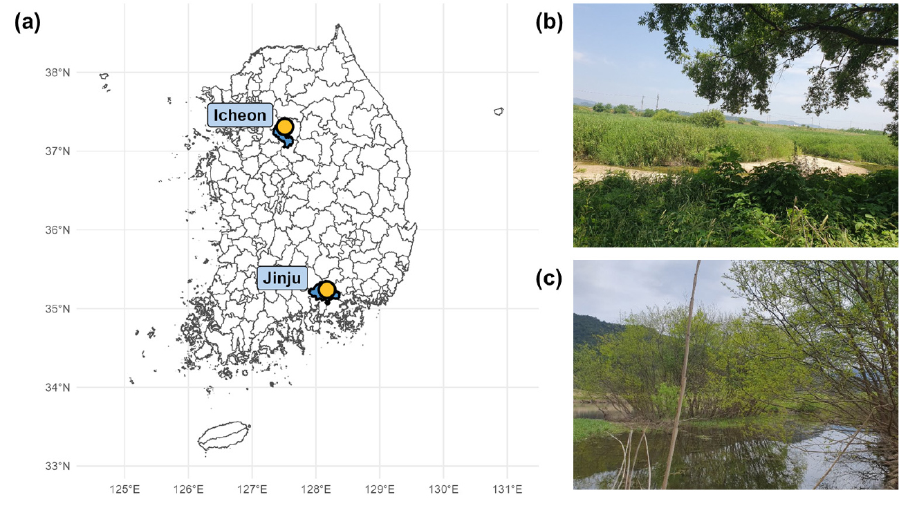
- Riverine wetlands represent the largest proportion of inland wetland area in South Korea, yet vegetation-specific soil carbon flux observations from these ecosystems remain scarce. In this study, heterotrophic soil respiration and methane emissions of three dominant vegetation types—Phragmites australis, Miscanthus sacchariflorus, and Salix koreensis—at two riverine wetland sites in Icheon and Jinju were measured and their environmental controls were examined. Across all vegetation types and sites, temperature was the primary driver of soil respiration, while temperature sensitivity (Q10: 1.65–2.62) was consistently greater in herbaceous soils than in woody vegetation soils. Most soils acted as weak methane sinks or showed negligible emissions; only Salix soils at lower elevations adjacent to the river channel exhibited episodic high methane emissions. A classification and regression tree analysis revealed moisture content of 43% and temperature of 25°C as critical thresholds for a sharp increase in methane emissions, suggesting that methane dynamics in these wetlands are driven less by gradual seasonal shifts than by the crossing of discrete environmental thresholds. Results of this study highlight that carbon budgets of riverine wetlands cannot be adequately characterized by vegetation type alone; microtopography-driven spatial variation in hydrological and edaphic conditions must also be considered.
- COLLAPSE
하천형 습지는 국내 내륙습지 면적의 가장 큰 비율을 차지하지만, 식생 유형에 따른 토양 탄소 플럭스에 대한 현장 관측 연구는 매우 제한적이다. 본 연구는 이천과 진주의 하천형 습지에서 갈대, 물억새, 버드나무 세 식생 유형별 종속영양 토양 호흡량과 메탄 발생량을 관측하고, 이를 조절하는 환경 요인을 분석하였다. 토양 호흡량은 식생 유형이나 조사지에 관계없이 온도가 지배적인 조절 요인이었으며, 온도 민감도(Q10: 1.65~2.62)는 초본류(갈대, 물억새) 토양에서 목본류(버드나무)보다 높게 나타났다. 메탄은 대부분의 토양에서 흡수되거나 미미한 배출 수준에 그쳤으나, 하천 인접 저지대에 위치한 버드나무 토양에서만 간헐적인 대량 배출이 나타났다. 분류·회귀나무 분석에서 수분 함량 43%와 온도 25°C가 메탄 급증의 임계점으로 도출되어, 메탄 발생이 계절적 변화보다 특정 임계 조건의 충족 여부에 좌우됨을 확인하였다. 이러한 결과는 하천형 습지의 탄소 수지를 평가할 때 식생 유형뿐 아니라 미시 지형에 따른 수문·토양 조건의 공간적 차이를 반드시 고려해야 함을 시사한다.
-
Soil Environmental Variation and Carbon Fluxes across Vegetation Types in a Riverine Wetland
-
Original Article
- Spatial Variability of N2O Dynamics in Tropical Headwater Streams of Madagascar
- Vonihanitriniaina D. Z. Andriamanantena R., Hyunyoung Oh, Yeonjoo Kim
- The evasion of nitrous oxide (N2O) from tropical rivers represents a substantial contribution but poorly constrained source of atmospheric N …
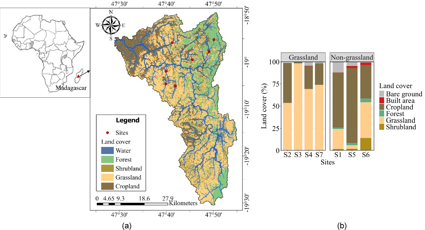
- The evasion of nitrous oxide (N2O) from tropical rivers represents a substantial contribution but poorly constrained source of atmospheric N2O, particularly in African river systems. Here, we investigated the spatial variations of concentration and fluxes of N2O from rivers, and their environmental controls in seven tropical streams of Ikopa in Madagascar, characterized by contrasting land-cover compositions. N2O supersaturation was observed with concentrations ranging from 7.76 to 47.6 nmol L-1. Diffusive N2O fluxes spanned from 24.53 to 638.94 µmol m-2 d-1 and were generally higher than values reported for many tropical rivers. Grassland- dominated rivers showed numerically higher N2O concentrations and fluxes, but differences between land-cover types were not statistically significant. Multivariate analysis showed contrasting environmental conditions, separating flow-dominated settings from nutrient-retentive environments formed by higher NH4+, total phosphorus, and depth. The results suggest that N2O concentrations and fluxes in Ikopa streams are regulated by coupled hydrological and biogeochemical heterogeneity. Shallow and high-flow conditions may enhance sediment-water exchange, turbulence, and coupled nitrification-denitrification processes. Moreover, elevated DOC: NO3- ratios indicate that internal microbial nitrogen cycling may contribute to N2O production under localized redox conditions. By providing critical primary data from a vastly underrepresented region, this study contributes to refining regional estimates of African riverine N2O emissions. - COLLAPSE
-
Original Article
-
Investigation of Lateral Earth Pressure Characteristics of Earth Anchor Retaining Walls Using Field Monitoring Data in Jeju Island
현장계측자료를 이용한 제주지역 어스앵커 흙막이벽의 측방토압 특성 연구
-
Gi-hyeon Hwang, Seung-Hyun Kim, Dong-Wook Lee
황기현, 김승현, 이동욱
- This study analyzes the lateral earth pressure of anchor-supported retaining walls using field monitoring data from excavation sites in Jeju Island and …
본 연구는 제주도 굴착 현장의 계측 데이터를 활용하여 앵커식 흙막이벽의 측방토압을 분석하고, 합리적이고 경제적인 설계 방안을 제시하고자 하였다. 수평변위는 벽체 강성이 클수록, …
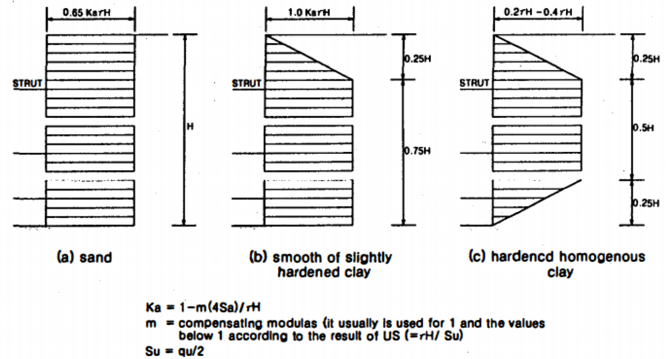
- This study analyzes the lateral earth pressure of anchor-supported retaining walls using field monitoring data from excavation sites in Jeju Island and proposes a rational and economical design approach. Horizontal displacement tends to decrease with increasing wall stiffness, improved ground conditions, and lower excavation depth. Although numerical analysis reproduces the overall deformation trends, discrepancies are observed in both the magnitude and location of maximum displacement. These differences are considered to result from limitations of the constitutive model and uncertainties in geotechnical parameters. Therefore, accurate prediction of retaining wall behavior requires appropriate selection of analytical models and the use of reliable geotechnical parameters.
- COLLAPSE
본 연구는 제주도 굴착 현장의 계측 데이터를 활용하여 앵커식 흙막이벽의 측방토압을 분석하고, 합리적이고 경제적인 설계 방안을 제시하고자 하였다. 수평변위는 벽체 강성이 클수록, 지반조건이 양호할수록, 터파기고가 낮을수록 감소하는 경향을 보였다. 수치해석은 전반적인 변형 경향을 재현하였으나, 최대변위의 크기와 발생 위치에서 차이가 나타났으며, 이는 구성모델의 한계와 지반정수의 불확실성에 기인하는 것으로 판단된다. 따라서 흙막이 벽체 거동의 정확한 예측을 위해서는 적절한 해석모델의 선정과 신뢰성 높은 지반정수의 적용이 필요하다.
-
Investigation of Lateral Earth Pressure Characteristics of Earth Anchor Retaining Walls Using Field Monitoring Data in Jeju Island

Journal Informaiton
 Ecology and Resilient Infrastructure
Ecology and Resilient Infrastructure


응용생태공학회
Room 1514, #20, Teheran-ro 25-gil, Gangnam-gu, Seoul 06130, Korea
Tel: +82-2-552-7550 / Fax: +82-2-552-7549 / E-mail: kseie2013@gmail.com Copyright© Korean Society of Ecology and Infrastructure Engineering. Powered by APUB
Tel: +82-2-552-7550 / Fax: +82-2-552-7549 / E-mail: kseie2013@gmail.com Copyright© Korean Society of Ecology and Infrastructure Engineering. Powered by APUB